


How Real-Time Survey Data is Transforming Decision-Making on Marine Job Sites
Marine construction projects have always depended on accurate survey data, but the way that data is collected and used is evolving rapidly. Traditional workflows relied heavily on post-processing, where survey crews collected data in the field and analyzed it later in the office. Today, real-time survey data is enabling teams to make decisions while work is still underway, improving efficiency, reducing costly errors, and helping projects stay on schedule in complex marine environments.
The Shift From Post-Processing to Real-Time Insight
For decades, hydrographic surveying followed a predictable pattern. Crews collected bathymetric and positioning data in the field, then processed it after returning to the office. While this approach provided reliable results, it introduced delays that limited how quickly decisions could be made on active job sites.
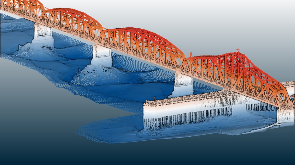
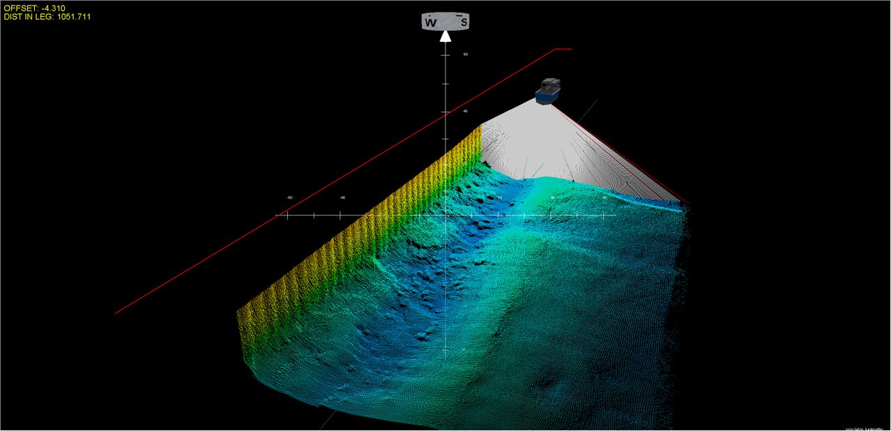
Modern survey technologies now allow data to be visualized and verified in real time. Multibeam sonar systems provide full coverage of the seabed rather than relying on spaced survey lines, giving operators a more complete understanding of underwater conditions as they work. When paired with precise positioning and motion sensing, these systems allow crews to identify irregularities and verify progress immediately.
Contractors looking to streamline operations are increasingly adopting integrated marine survey systems that combine multiple technologies into a single workflow. This approach reduces setup complexity while delivering accurate, georeferenced data directly in the field.
Why Real-Time Data Matters on Marine Job Sites
Marine environments are constantly changing. Tides, currents, sediment movement, and equipment positioning all influence site conditions. Without real-time visibility, crews often rely on data that may no longer reflect actual conditions.
Real-time survey data allows operators to continuously monitor progress and make adjustments as needed. In dredging applications, crews can confirm cut depths immediately, reducing the risk of over-dredging or leaving material behind. In construction projects, real-time data helps verify alignment and positioning, ensuring that work remains within design tolerances.
This ability to act on current information improves productivity and reduces uncertainty. Instead of waiting for processed results, teams can respond instantly, keeping operations efficient and controlled.
Improving Accuracy Through Integrated Technologies
Accurate survey data depends on the coordination of multiple systems. Positioning, motion sensing, and acoustic measurements all contribute to the final result. When these components operate independently, the potential for misalignment or calibration errors increases.
Integrated systems address this challenge by combining these elements into a unified solution. Global navigation satellite systems provide precise positioning, while inertial sensors account for vessel motion such as pitch, roll, and heave. When paired with multibeam sonar, these systems generate consistent and reliable data in real time.
This level of integration simplifies calibration and reduces the likelihood of measurement errors. By minimizing manual inputs and synchronization issues, crews can focus on collecting data rather than troubleshooting equipment.
Reducing Rework and Project Delays
Rework remains one of the most costly challenges in marine construction. Errors in survey data can lead to incorrect excavation depths, misaligned structures, or incomplete installations. In traditional workflows, these issues may not be identified until after processing is complete.
Real-time data changes this dynamic. Crews can verify results as they work, identifying discrepancies immediately and correcting them before moving forward. This is particularly valuable in dredging and as-built verification, where precise measurements are critical.
By reducing the need for repeat surveys and corrective work, real-time systems help keep projects on schedule and within budget. The ability to validate results in the field provides greater confidence in the work being completed.
Streamlining Mobilization and Field Workflows
Mobilization has historically been a time-intensive process in marine surveying. Setting up multiple components, aligning sensors, and performing calibrations can delay the start of operations, especially on vessels with limited space.
Advancements in system design are helping to simplify this process. Compact, integrated solutions reduce the number of components required and allow for faster deployment. In many cases, systems can be installed and operational with minimal setup time, making them well suited for projects that require quick mobilization.
Simplified workflows also improve usability for field crews. With fewer steps involved in setup and operation, teams can begin collecting data sooner and maintain consistent performance throughout the project.
Supporting the Growth of USVs and Small Vessel Operations
The use of unmanned surface vessels and small craft is increasing across marine construction and surveying applications. These platforms offer flexibility and cost advantages, but they also require equipment that is lightweight, efficient, and easy to deploy.
Real-time survey systems designed with compact form factors are particularly well suited for these environments. Their ability to operate on smaller vessels or temporary platforms allows contractors to expand their capabilities without the need for large, specialized survey vessels.
This flexibility is driving broader adoption of real-time survey technologies, especially in projects where access is limited or rapid deployment is required.
Turning Data Into Actionable Decisions
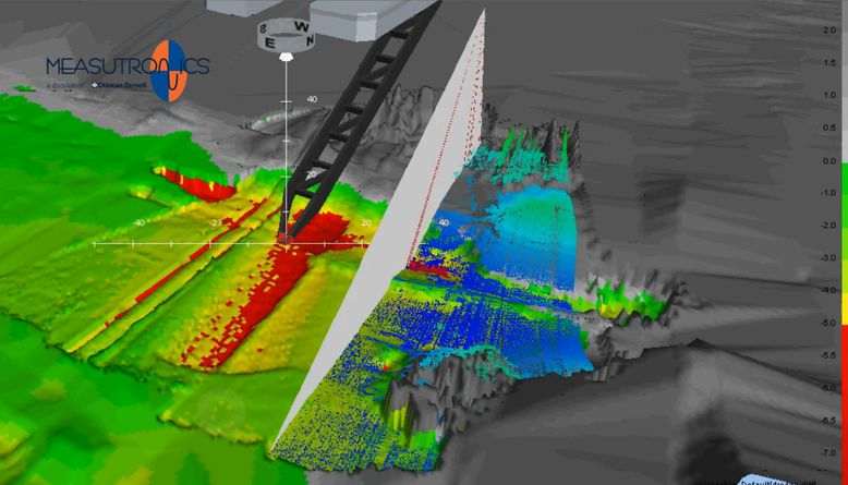
The true value of real-time survey data lies in its ability to support decision-making. When data is immediately available and presented clearly, it becomes a practical tool for managing operations rather than just a record of completed work.
Real-time visualization allows teams to compare current conditions with design models, identify deviations, and make adjustments instantly. This improves communication between field crews and project managers, ensuring that everyone is working with the same accurate information.
As projects become more complex, the ability to quickly interpret and act on data will continue to play a critical role in successful project delivery.
The Future of Marine Surveying and Construction
The adoption of real-time survey data reflects a broader shift toward more efficient and data-driven construction practices. As technology continues to evolve, contractors are seeking solutions that reduce complexity while improving accuracy and reliability.
Many are turning to advanced hydrographic survey equipment that integrates multiple functions into a single system, enabling faster deployment, simplified operation, and consistent performance in challenging environments. These capabilities are becoming increasingly important as marine projects demand higher levels of precision and efficiency.
In the years ahead, real-time data will become a standard expectation rather than a competitive advantage. Contractors who embrace these technologies will be better equipped to manage risk, control costs, and deliver projects with confidence.
What are the benefits of real-time survey data in marine construction?
Real-time survey data allows crews to monitor conditions instantly, improve accuracy, reduce rework, and make faster decisions during marine construction projects.
How does multibeam sonar improve marine surveying?
Multibeam sonar provides complete seabed coverage in real time, helping surveyors identify underwater features and verify project progress more efficiently than traditional single-beam methods.