Chapter 1 – Introduction
For a complete version of this document click here.
OBJECTIVES
This report is intended for planning, regulatory, and other local government officials whose duties include some involvement in shoreline erosion prevention measures. The discussion is limited to the shorelines of sheltered waters that are not subject to the direct action of undiminished oceanic waves. These would include bays, sounds, tidal rivers, and the Great Lakes.
The erosion problems that are experienced today are often caused by failure to recognize that shorelines have always been areas of continuous and sometimes dramatic change. This lack of understanding of shoreline processes has been catastrophic for many property owners, both private and public. An objective of this report is to show that the situation is not without remedies and a large variety of reasonably low cost alternatives are available. However, it must be cautioned, that while appearing deceptively simple, most of them require careful judgment and design, and can entail considerable investment to correctly implement. Therefore, before any action is taken, it is important to recognize and understand the natural forces at work in the general area of a proposed project. By considering the overall view rather than conditions just at the site, a broader perspective of the problem and possible solutions is developed, and a more informed decision can be made.
The solutions presented herein are referred to as “low cost”. That does not necessarily mean they are “cheap”. In fact, practically any properly implemented shore protection method is expensive. The term “low cost” simply means that the various measures are commensurate with the value of property being protected and they are among the lower priced options available. Whether a solution is considered a low cost alternative or not, however, is up to the individual or community installing it. The cost of the project must be weighed against both the objective and subjective value of what is being lost to erosion.
This report has five sections. The first provides a basic understanding of shoreline processes and the causes of erosion The second describes a variety of devices as possible solutions The third provides guidance for selection among the protection alternatives. The fourth outlines permit requirements. And since this report serves only as a introduction, the fifth provides a directory of other sources of help.
The United States Army Corps of Engineers has produced this report as a public service. Unless otherwise noted, the devices described herein have been utilized at sites throughout the United States to slow or arrest erosion problems. However, successful use of the material presented depends on numerous factors that are peculiar to individual situations. Therefore, the government cannot guarantee that any of the described methods will be successful for any specific application, nor does the government necessarily endorse any of the devices presented.
SHORELINE PROCESSES
The first requirement in solving an erosion problem or reviewing a proposed solution is to understand the processes and forces at work. Without such basic knowledge, any solutions are likely to be misguided and inappropriate. The following presents basic information about shoreline processes as a foundation for the subsequent discussion.
Wave Action
While waves are always present on the open coast, they are not continuously active in sheltered waters. Nonetheless, they are still the major cause of erosion in all coastal areas. Understanding how wave action influences shoreline processes requires familiarity with several basic characteristics of waves: height, period, and length (Figure 1). Wave height is the vertical distance between the wave crest and trough. Wave period is the time it takes two successive wave crests to pass a stationary point, and wavelength is the distance between successive crests.
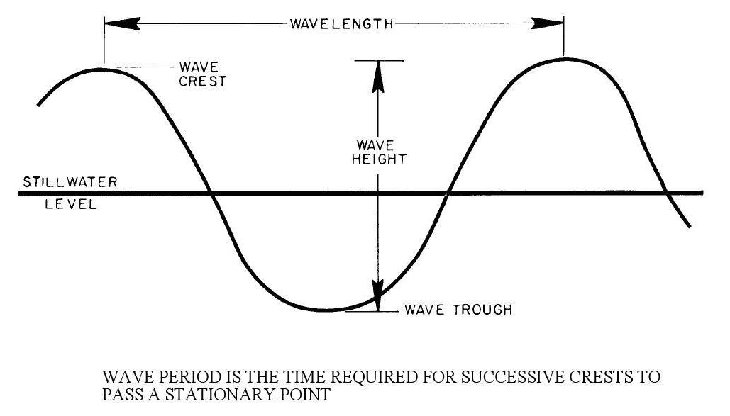
As a wave moves through deep water (depths greater than one-half the wavelength), these basic characteristics do not change. When a wave approaches shallower water near the shore, the period remains constant, the forward speed and wavelength decrease, and the height slightly increases. The wave begins to “feel the bottom”, and its profile steepens as its gently rolling shape sharpens to a series of pointed crests with intervening flat troughs. When the wave height is about 80 percent of the water depth, the wave can no longer steepen and it breaks. For example, a 5-foot wave breaks in a water depth of about 6.5 feet.
Important wave properties are demonstrated when a series of regular waves meet a solid barrier, such as a breakwater (Figure 2). Wave diffraction occurs when the waves pass the barrier, structure. Diffraction causes waves to form in the shadow zone that are smaller than waves in the adjacent unprotected zones.
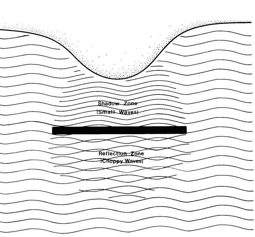
Wave reflection occurs on the offshore side of the breakwater While waves passing the structure are diffracted, the portions striking the breakwater are reflected like a billiard ball from a cushion. If the structure is a smooth vertical wall, the reflection is nearly perfect, and if the wave crests are parallel with the breakwater, the reflected and incoming waves will reinforce each other to form standing waves which are twice as high as the incoming waves. These can cause considerable scouring of the bottom. If the waves approach at an angle, no standing waves form, but the resulting sea-state is choppy because the reflected waves cross the path of incoming waves. This could also contribute to bottom scour.
The final important wave characteristic is evident when waves break either on a beach or structure. The uprush of water after breaking is called runup and it expends the wave’s remaining energy. The runup height depends on the roughness and steepness of the structure or beach and the characteristics of the wave.
The wave generation process depends on several important factors, the most prominent being wind, although the movements of pleasure craft and large vessels are also significant sources of wave activity. The height of wind-driven waves depends on the wind speed, duration, fetch length, and water depth. Wind speed is obviously important, but duration (length of time the wind blows) must also be considered because wind action must be sustained for wave growth. Fetch is the over-water distance wind travels while generating waves. At a given site, the maximum fetch length, or longest over-water distance, is generally the most important. Less important, but still critical, is the average water depth along the fetch. Deeper water allows for somewhat larger waves because of decreased bottom friction.
Sediment Transport
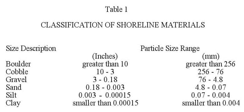
The large variety of shoreline materials ranges from rock cliffs to boulders, cobbles, gravel, sand, silt, and clays. Geologists and engineers have developed several classification systems for these materials and an example is given in Table 1.
Rock characterizes cliff shorelines, such as the northern California shore. Boulders are often present at the base of such cliffs because of rock fracturing and weathering. Cobbles and gravels are prevalent beach materials in the Pacific Northwest, Alaska, and the Great Lakes area. Sand, the most common shoreline material, is found in virtually all coastal areas. Silts and clays generally occur on bluff shorelines or marshes, such as along the Great Lakes and various bays.
Littoral (shoreline) materials are derived from the deterioration and erosion of coastal bluffs and cliffs; the weathering of rock materials found inland and transported to the shore by rivers and streams; the disintegration of shells, coral or algae; and the production of organic material (generally peat) by coastal wetlands.
Failure or erosion of a bluff causes material to be deposited at the base. Waves sort this material and carry the fine-grained silts and clays far offshore where they settle to the bottom. The original deposit is eventually reduced to sand and gravel which form a beach. If no other littoral material is carried to the site by waves, even the sand and fine gravel will eventually disappear down the coast or offshore, leaving only coarse gravel behind. However, a new supply of material may be deposited on the beach by a fresh failure of the bluff, and the process begins again. In most cases, littoral materials comprising beaches are derived from erosion of the shoreline itself.
Rivers and streams carry sediments eroded from mountains, forests, and fields, particularly during floods. The sediment is usually smaller than sand because coarser particles are not easily transported by most streams. Except where streams traverse sandy drainage basins, the contribution to beach building from this source is usually smaller than from the first source.
Coral reefs, shells, and other plant or animal matter are another material source. They gradually break and weather into carbonate particles which are, for instance, the primary components of beaches south of Palm Beach, Florida. Swamps, marshes, and coastal wetlands produce peats and other organic matter. Too light to remain in place under continued wave action, they are ultimately washed offshore unless stabilized.
Littoral materials are transported along the shore as shown in Figure 3. As waves approach the shore, they move to progressively shallower water where they bend or refract until finally breaking at an angle to the beach. The broken wave creates considerable turbulence, lifting bottom materials into suspension and carrying
-
 SPW911 Sheet Pile Design Software
Rated 5.00 out of 5$150.00 – $599.99Price range: $150.00 through $599.99
 -
 Sheet Pile Design (PDF Download)
Rated 5.00 out of 5$89.00
 -
 Pile Driving (PDF Download)
$89.00
-
 Marine Construction Volumes 1 & 2 (PDF Download)
$157.00
-
 Pile Driving (Book)
$89.00


