


Coastal Protection: Marine Construction Solutions for Erosion and Other Issues
View the complete article here.
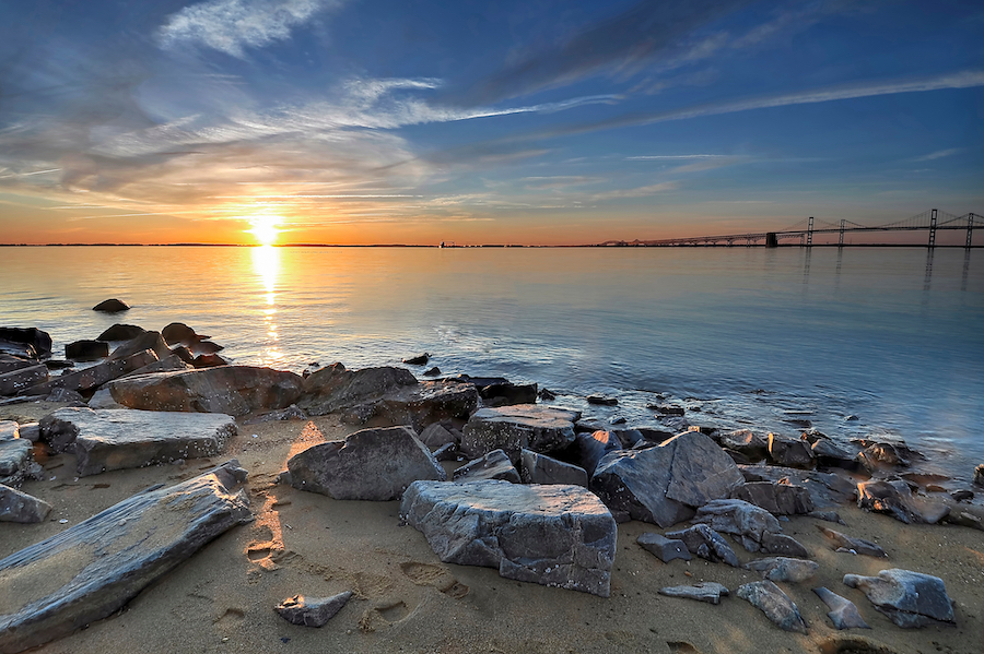
Coastlines, the dynamic boundary between land and sea, are perpetually shaped by a myriad of processes and forces—both natural and man-made. From the gentle yet relentless force of erosion on the East Coast beaches to the dramatic and abrupt changes caused by tectonic activities, such as the 2004 Indian Ocean tsunami, the interplay of these factors continually redraws our world’s shorelines. Understanding these forces, as well as the solutions offered by marine contractors, are both essential for sustainable coastal management, habitat preservation, and the safeguarding of human infrastructure and livelihoods.
Problems Requiring Coastal Protection
Given the array of forces that impact our coastlines, multiple pressing challenges emerge that necessitate coastal protection. Chief among these are…
Erosion
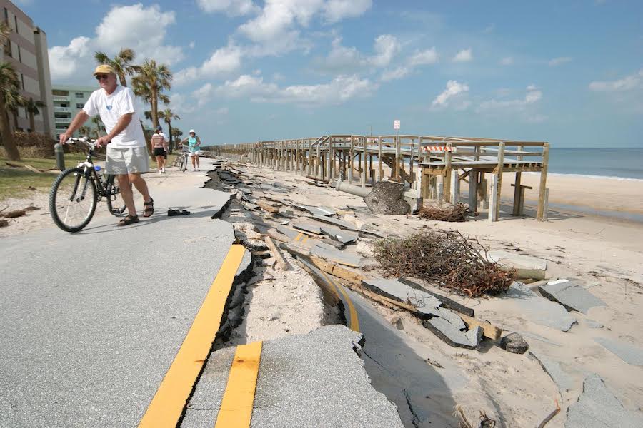
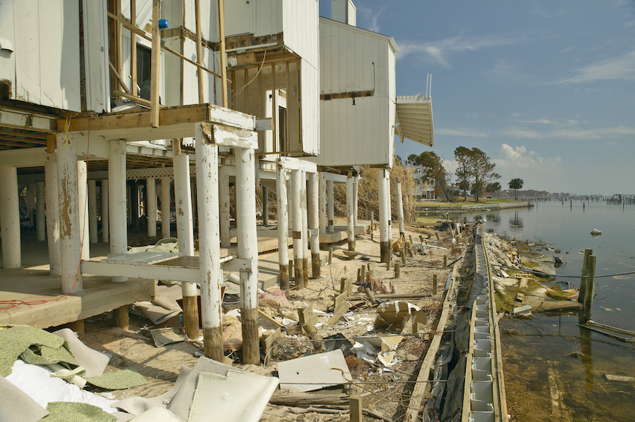
Erosion represents the natural and gradual process where land materials like soil and sand are removed and worn away by forces such as water, wind, ice, and gravitational movement. A prime example of erosion is the frequent sand erosion seen on beaches along the East Coast of the United States. Constant wave action—especially after hurricanes and major storms—diminishes the shoreline. Over time, these eroded beaches can lead to significant loss of land, habitat, and infrastructure—requiring preventive or remedial interventions.
Tectonic Activity
Tectonic activity encompasses movements within the Earth’s crust—like earthquakes, volcanic eruptions, and shifting of tectonic plates. The devastating 2004 Indian Ocean earthquake and ensuing tsunami, triggered by tectonic plate movement, caused massive coastal erosion and inundation across various countries. Natural geologic events such as this can quickly reshape coastlines and emphasize the unpredictable nature of coastal processes.
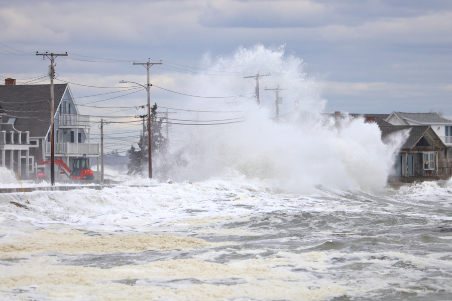
Storm Surges
Storm surges refer to an abnormal and significant rise in sea level that accompanies hurricanes or other intense storms. Their destructive power was evident during Hurricane Katrina in 2005. This hurricane led to a significant storm surge that caused the levees in New Orleans to breach, resulting in catastrophic flooding. The aftermath showcased the critical need for improved coastal defense mechanisms.
Tidal Forces
Caused by the gravitational effects of the moon and sun, tidal forces lead to the daily rising and lowering of ocean tides. Places like the Bay of Fundy in Canada experience the world’s highest tides, leading to significant sediment movement and coastline reshaping. These intense tidal variations can impact local ecosystems, alter sediment transport, and necessitate adaptive infrastructure.
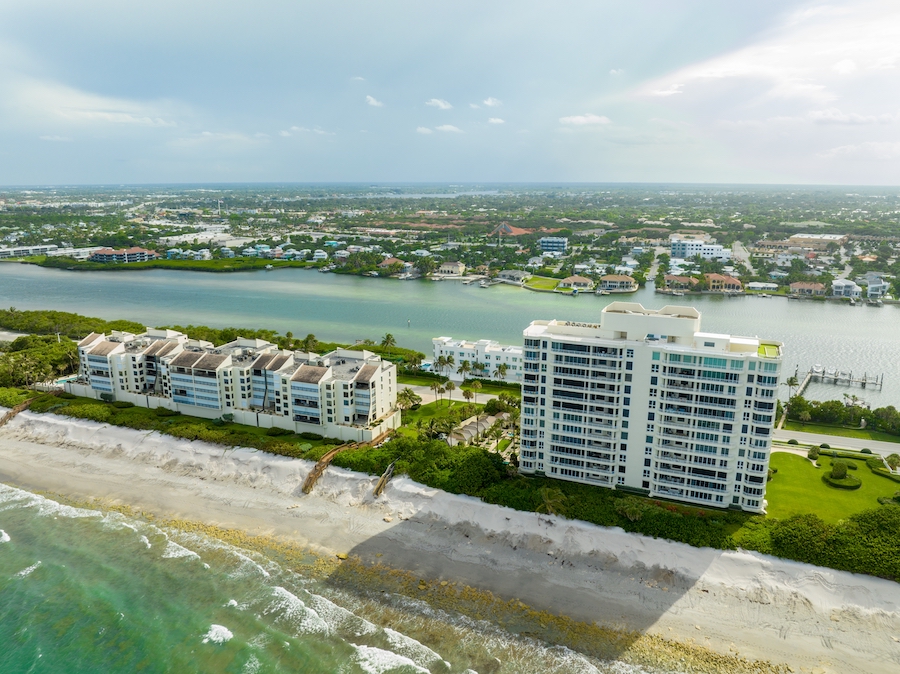
Human Activity
Direct or indirect human actions have profound impacts on the environment and coastal stability. For example, coastal development in Florida has altered natural sand movement patterns. Over time, these human-made disruptions require interventions such as periodic beach nourishment to replace lost sand. The compounding effects of development, pollution, and recreational activities emphasize the need for sustainable shoreline management.
River Discharge
River discharge refers to the flow of water and transported sediment from rivers into seas or oceans. A notable example is the Mississippi River, which deposits vast amounts of sediment into the Gulf of Mexico—forming a continually shifting and changing delta. These sediment inputs can build new lands, but can also smother important habitats or alter local shorelines.
Groundwater Changes
Variations in groundwater levels can induce swelling or land subsidence (the sinking or downward settling of the Earth’s surface). For example, in certain areas of California, over-extraction of groundwater has led to significant land subsidence. This reduced ground elevation heightens the risk of flooding, especially in coastal regions—making these areas vulnerable to sea-level rise and storm surges.
Wave Action
The movement and force of waves can transport, deposit, or erode sediment along coastlines. Take the North Shore of Oahu in Hawaii, for example. During winter, this region faces powerful waves that lead to prominent coastal erosion. Over the years—such forceful wave action can result in the loss of habitats, destabilization of infrastructure, and the need for erosion control measures.
Wind Action
Wind has the capability to move sediment and reshape coastal landscapes. Coastal dune systems, like those in North Carolina, are particularly sensitive. In this case, potent winds can drive sand inland—reshaping dunes and potentially burying vegetation or even infrastructure. This not only alters landscapes but can impact local ecosystems and necessitate mitigation efforts.
Loss of Vegetative Cover
The removal or destruction of vegetation that naturally safeguards coastlines against erosion has profound impacts. Coastal mangrove forests in Southeast Asia are an ideal example. When these forests are cleared for purposes like aquaculture or development, the shoreline becomes more exposed to erosion and storm damage. These mangroves, along with other coastal vegetation, provide crucial buffers and habitat—underscoring the importance of their preservation.
Sea-Level Rise
Whether you believe seal-level rise is caused by humans or not, there is an undeniable increase in the average level of the world’s oceans. This phenomenon is often linked to global warming due to the thermal expansion of seawater and the melting of glaciers and polar ice caps. For example, small island nations like the Maldives are facing existential threats from this rise. As sea levels increase, these nations witness decreasing land area—leading to potential displacement of communities and loss of freshwater sources.
Shore Protection Methods for Marine Contractors
Marine contractors employ a range of shore protection methods to mitigate the adverse effects of erosion, sea-level rise, and other coastal challenges—ensuring the longevity of coastal infrastructures and habitats. These methods, tailored to specific site needs and environmental conditions, play a crucial role in safeguarding our coastlines against the relentless forces of nature.
Bulkheads and Seawalls
Bulkheads and seawalls serve a primary function—to protect coastlines, properties, and infrastructure from the erosive force of waves and tidal actions. While both are used interchangeably, there’s a subtle difference—seawalls generally guard against waves, while bulkheads retain the soil from eroding away.
A prime example is the Galveston Seawall in Texas. Built after the devastating 1900 hurricane, this 10-mile long structure has protected the city of Galveston from numerous storms and hurricanes. Constructed mainly of concrete, it has undergone various modifications and improvements over the years—showcasing the importance and longevity of such protective measures.
When constructing seawalls—the choice of materials such as wood, steel, or concrete depends on factors like stress and budget. Prior to construction—an assessment of the site’s soil, tides, and environmental impact is conducted. Depending on soil stability, foundations might involve deep pilings or trenches filled with stable materials. The erected wall often features a curve or slant for wave deflection, with its dimensions based on anticipated wave action. After construction—a cap is added for wave prevention, and the adjacent land is backfilled for stability and water runoff management.
Application tips:
- Regular inspection: Over time, even the most robust seawalls and bulkheads can degrade. Regular inspections can help identify issues like cracks or structural weaknesses early on.
- Eco-friendly materials: Consider environmentally-friendly materials that do not leach harmful chemicals into the water. Some newer vinyl and composite materials offer longevity without environmental harm.
- Consider wave reflectivity: While these structures are designed to reflect wave energy, too much reflection can exacerbate erosion in front of the wall. It’s essential to strike a balance or consider adding materials like riprap in front to dissipate energy.
- Incorporate drainage: Without proper drainage, water can accumulate behind the wall—leading to increased pressure and potential wall failure. Incorporate weep holes or other drainage mechanisms to ensure water doesn’t build up.
Revetments
Revetments are structures designed to absorb wave energy, preventing the erosion of coastlines and protecting valuable infrastructure and property. Typically, they cover the bank or cliff with layers of rocks, rubble, or concrete units—ensuring a sloping barrier against the assaulting waves.
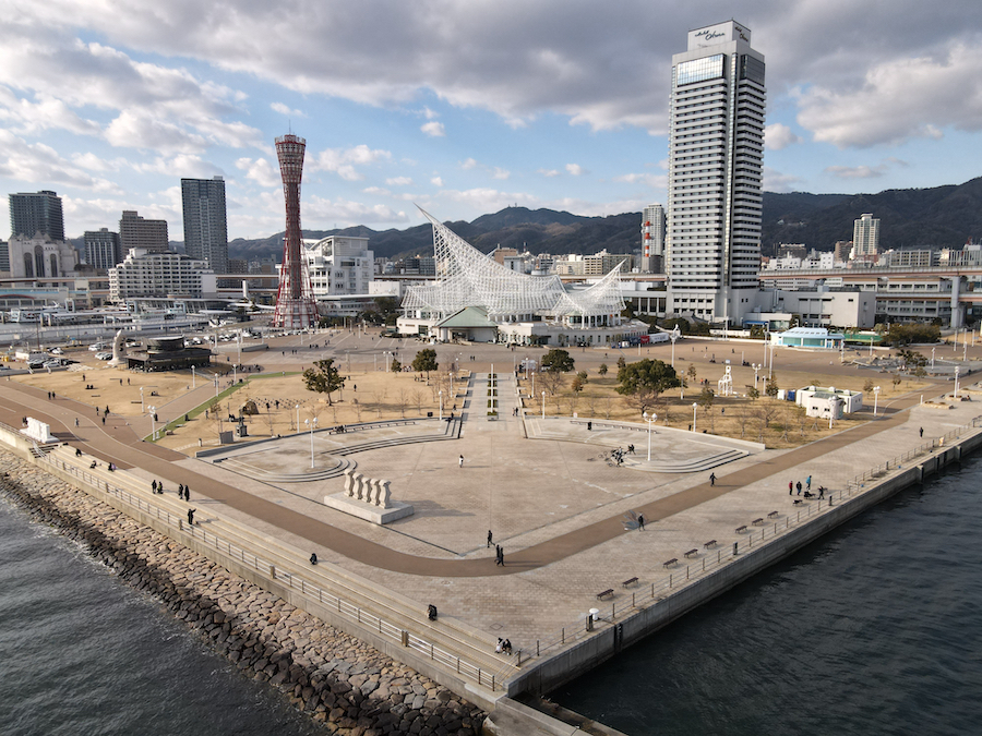
The Kobe Port Earthquake Memorial Park in Japan stands as a testament to the importance of revetments. After the devastating 1995 earthquake, the city redesigned its coastline using extensive revetments to protect against future tsunamis and storm surges.
Constructing a revetment begins with the selection of material—often rock, concrete, or rubble. The site undergoes evaluation to understand its slope, the force of expected wave action, and potential environmental impacts. Based on this, the revetment is designed with a specific slope and thickness to effectively absorb wave energy. After the foundational layer is established, usually of smaller rocks or concrete, the main revetment material is systematically layered. Over time, maintenance might involve replenishing or repositioning the materials to ensure the structure remains effective.
Application tips:
- Size matters: The size of the materials, especially rocks, should be proportionate to the expected wave energy.
- Eco-friendly approach: Consider integrating vegetation between the rocks to offer added protection and promote a more natural look.
- Maintenance: Regular inspections and periodic adjustments of the materials ensure the revetment remains effective.
- Slope adjustments: The slope of a revetment can be altered based on wave action. A steeper slope might be more suitable for areas with high wave energy.
Groins
Groins are structures built perpendicular to the shore, designed to interrupt water flow and trap sand. By doing so, they can prevent beach erosion and even help in beach widening.
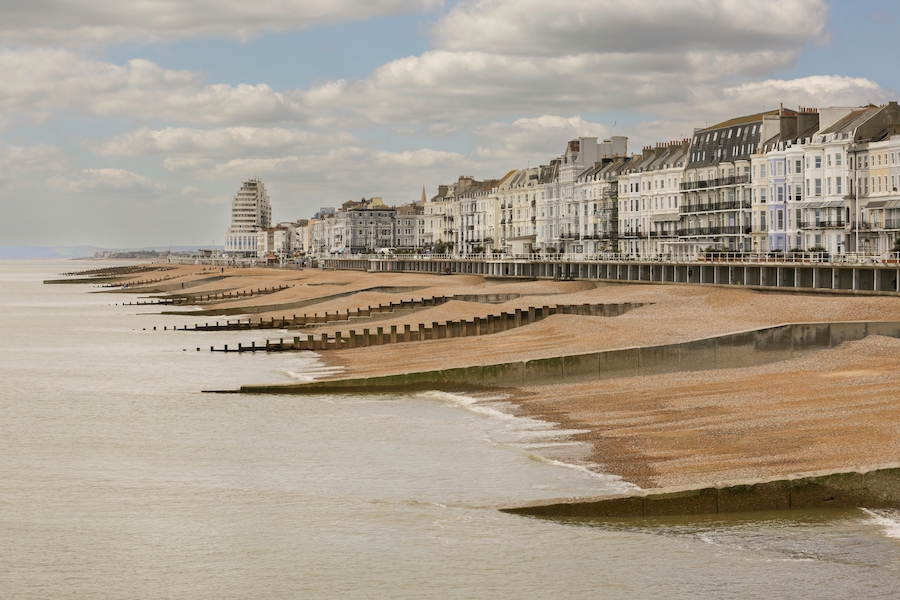
The coastline near Hastings, UK, provides a notable example of how groins are utilized. In this area, a series of groins have been constructed to manage beach erosion. These groins have played a vital role in trapping sand, helping to maintain a wider beach, as well as offering protection against the effects of tidal action and storm surges.
To construct groins, one begins with material selection—which can range from wood to concrete to large rocks. After determining the site’s requirements—like the extent of erosion, tidal movements, and beach slope—the groin’s size and orientation are finalized. Installation often involves digging or drilling into the seabed to ensure stability. Once erected, sand naturally accumulates on the updrift side—while potential erosion can occur on the downdrift side.
Application tips:
- Monitor effects: Groins can lead to erosion downstream. Regular monitoring ensures any negative effects are addressed promptly.
- Use in series: Instead of one long groin, a series of shorter groins can be more effective and environmentally friendly.
- Material longevity: Opt for materials that are durable and can withstand the constant force of waves and tides.
- Consider removal: If a groin proves to be more harmful than helpful, be prepared to modify or remove it.
- Engage with experts: The impact of groins on local ecosystems and sediment transport is complex. Collaborate with marine scientists to optimize their placement and design.
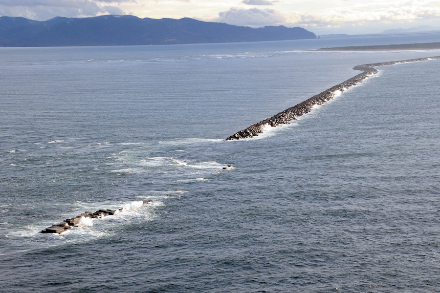
Jetties
Jetties are structures designed to maintain or deepen navigational channels, often constructed at the entrances to harbors or river mouths. They work by preventing the accumulation of sediment, ensuring smooth passage for ships and boats.
A noteworthy example is the Columbia River Jetty System in Oregon and Washington, USA. This extensive system helps maintain the navigation channel of one of the Pacific Northwest’s most important waterways, allowing for commercial and recreational boat traffic.
The construction of a jetty begins with determining its length and alignment to best guide the water flow and reduce sediment deposition. Materials such as large rocks, concrete blocks, or even steel sheet piles are chosen based on the site’s conditions. The chosen material is then strategically placed, often in a sloped manner, to create a barrier against sediment flow—but allow water to pass. Over time, jetties may require reinforcement or extensions—especially if sediment patterns change or if sea levels rise.
Application tips:
- Environmental assessment: Jetties can affect marine habitats, so a thorough environmental review is crucial before construction.
- Regular maintenance: Jetties can deteriorate due to harsh marine conditions, necessitating periodic checks and repairs.
- Avoid over-extension: Overly long jetties can negatively affect sediment transport, possibly causing issues downstream.
- Material integrity: Ensure that materials used can withstand corrosive saltwater and intense wave action.
- Work with hydrologists: To understand water and sediment flow patterns, collaborating with experts can optimize jetty design and placement.
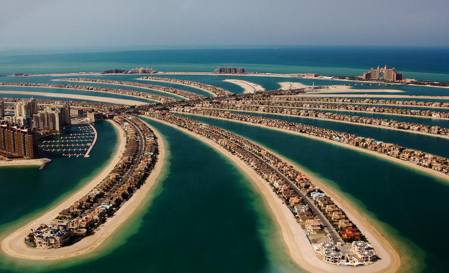
Breakwaters
Breakwaters are offshore structures built to break the force of incoming waves, providing calm waters behind them. They can be floating or fixed and are often used to protect harbors, anchorages, and marinas.
One famous example is the Palm Jumeirah in Dubai. The crescent-shaped breakwater protects the artificial island’s properties and beaches from the Gulf’s wave actions.
The construction of breakwaters begins with the design phase—taking into account wave heights, tidal actions, and desired calm area dimensions. Typically—large rocks, concrete caissons, or other heavy materials are employed. These are methodically layered or positioned offshore to create the desired barrier. As wave energy hits the breakwater, it’s dispersed, leaving calmer waters in its wake.
Application tips:
- Depth matters: Ensure the breakwater is constructed at an appropriate depth to effectively dissipate wave energy.
- Monitoring: Like other structures, breakwaters require regular checks to identify and rectify any wear-and-tear.
- Material sizing: The size of materials used should be proportional to the expected wave energy.
- Environmental considerations: Breakwaters can impact local marine life, so choose design and materials with this in mind.
- Flexible design: Given sea-level rise predictions, designs that can be adjusted or expanded in the future are advantageous.
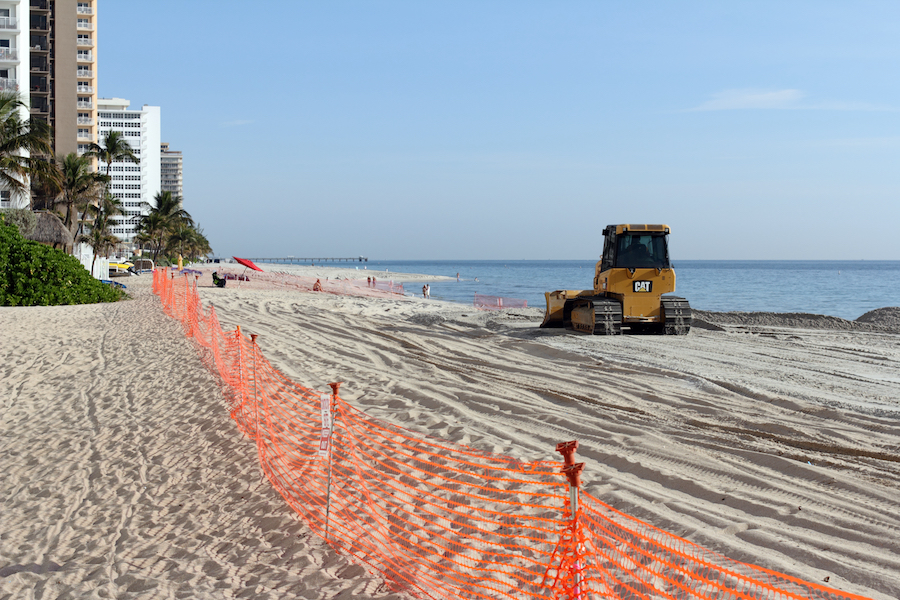
Beach Nourishment
Beach nourishment is the process of importing and depositing sand or other sediments from elsewhere to restore eroded beaches. It offers a softer solution compared to hard infrastructure, often enhancing beach aesthetics and recreation value.
South Florida stands out as a prime example, where periodic nourishment has helped counterbalance ongoing erosion—providing both protection for infrastructures and a space for recreation.
The process of beach nourishment begins with sourcing sediment—often sand—from offshore or inland sources. Using ships or pipelines, the sediment is transported and then spread across the eroded beach. Over time, tidal actions naturally shape this deposited material—integrating it into the existing beach.
Application tips:
- Quality over quantity: The sediment used should closely match the existing beach’s grain size and composition.
- Monitor sediment movement: Post-nourishment, it’s crucial to keep an eye on how the new sediment behaves—ensuring it remains effective.
- Consider local ecology: Importing sediment can impact local habitats, so an environmental assessment is essential.
- Frequency: Erosion doesn’t stop, so periodic re-nourishment might be needed—depending on local conditions.
- Public engagement: As beach aesthetics change post-nourishment, engaging with local communities can ensure acceptance and satisfaction.
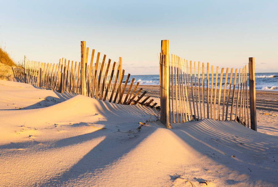
Dune Restoration
Dune restoration focuses on rehabilitating and stabilizing sand dunes—which act as natural barriers against wave action, tidal surges, and even wind. These formations not only shield coastal properties and ecosystems but also play a vital role in the preservation of biodiversity, hosting various plant and animal species.
One noteworthy example of dune restoration can be found on the Outer Banks of North Carolina. Over the years, human activity and storms degraded these dunes. Restoration efforts have since been employed to rebuild and vegetate them, ensuring the continued protection of this unique coastal environment.
The dune restoration process often starts with physical reshaping. Heavy machinery or manual labor can be used to move sand and create the dune’s foundational shape. At this point, vegetation—usually native grasses like American beach grass or bitter panicum—is planted. These plants play a crucial role as their root systems hold the dune’s sand in place, while their leaves trap more sand—allowing the dune to grow.
Application tips:
- Use native vegetation: Always opt for local plant species as they’re best adapted to the specific conditions and support local wildlife.
- Monitor dune health: Regularly check for signs of erosion or vegetation loss to address issues promptly.
- Limit human interference: Boardwalks or designated paths can help ensure that human activity doesn’t degrade the dunes.
- Incorporate sand fences: These can be used to trap wind-blown sand, aiding in dune buildup.
- Engage the community: Informing locals and visitors about the importance of dunes and the do’s and don’ts can lead to better preservation efforts.
Living Shorelines
Living shorelines aim to protect coastal areas from erosion by integrating natural elements—such as marsh plants, oysters, and other native species—with minimal built infrastructure. Unlike hard protective methods—living shorelines enhance biodiversity, filter pollutants, and provide habitats for marine life.
A prime example is found in the Chesapeake Bay region, where traditional erosion controls like bulkheads were leading to habitat loss. In response, communities have started embracing living shorelines—combining oyster reefs, native grasses, and limited rock structures to protect properties while preserving the bay’s rich ecology.
To construct a living shoreline—initial site assessments focus on the local ecosystem, tidal actions, and soil stability. Based on these factors, a design integrating natural habitats and minimal structural elements is drafted. Essential steps include planting salt-tolerant vegetation like cordgrasses and introducing shellfish, which together form a resilient buffer against waves. In some instances, rocks or coir logs can be placed strategically to reduce wave energy and offer initial stability until the vegetation takes root.
Application tips:
- Native species: Prioritize local plant species and shellfish that are adapted to the specific conditions and benefit local biodiversity.
- Regular maintenance: While living shorelines are self-sustaining once established, it’s essential to monitor vegetation health and replace any lost plants or shellfish.
- Adaptive design: Recognize that coastal conditions can change. Designs should be flexible enough to evolve with changing shore dynamics.
- Engage stakeholders: Ensure community understanding and buy-in. This can ensure the sustained health and respect for the living shoreline.
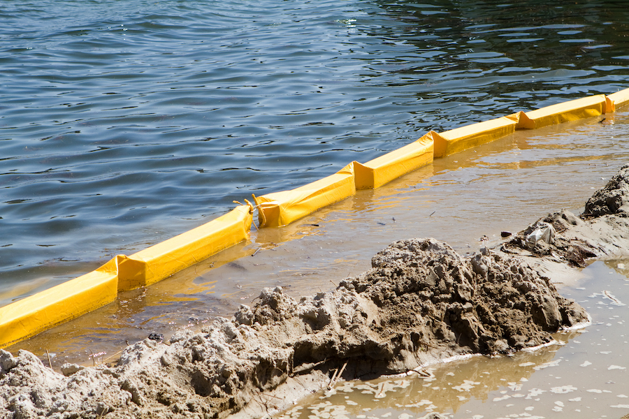
Silt Curtains
Silt curtains, often known as turbidity curtains or sediment barriers, are intended to prevent sediment and silt from migrating into water bodies during marine construction or dredging activities. By doing so—they protect aquatic habitats, ensure clarity of water, and comply with environmental regulations.
A notable example of their application was during the construction of the Panama Canal Expansion, where silt curtains played a crucial role in mitigating the environmental impact of dredging operations—ensuring the protection of marine life and water quality.
The construction process for silt curtains starts with a comprehensive site assessment—evaluating factors like water currents, depth, and anticipated sediment loads. This assessment determines the suitable type and size of the silt curtain. There are three primary types: Type I for calm waters such as ponds and canals, Type II for waters with moderate currents, and Type III for fast-moving waters or coastal environments. Once chosen, the curtain—which consists of a floatation section on the top and a weighted bottom—is anchored to the seabed. This positioning ensures it spans the required depth to effectively contain sediment suspension.
Application tips:
- Deployment depth: Ensure the curtain is deployed to the right depth, leaving a gap between its bottom and the seabed to allow for aquatic life movement.
- Regular monitoring: Regularly check for damages or gaps, and ensure that the curtain is not overwhelmed by sediment loads—which can cause it to become ineffective.
- Environmental considerations: Before deploying a silt curtain, consult local environmental agencies or bodies to ensure the curtain won’t harm sensitive habitats or species.
- Effective anchoring: Curtains should be anchored securely to prevent them from drifting, but with enough flexibility to adapt to changing conditions.
- Consider curtain lifespan: Silt curtains are not permanent solutions. They degrade over time and, depending on the material, may need replacement or removal after their effective period. Always have a plan for the curtain’s end-of-life.
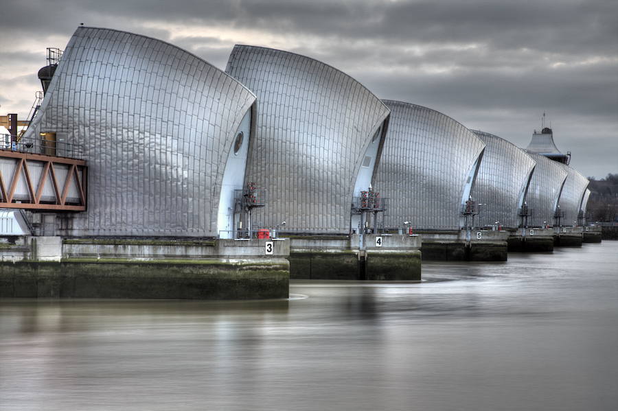
Tidal Barriers
Often referred to as storm surge barriers or sea gates, tidal barriers are specifically designed to prevent sea-based threats—such as tidal surges or high waves—from entering estuaries or river mouths—thus protecting inland areas. These barriers serve as temporary sea walls, only rising or closing during potential flooding events, ensuring minimal disruption to the natural tidal flow and marine navigation during normal conditions.
The Thames Barrier in London is an excellent example of a tidal barrier’s function. Built to prevent the floodplain of the River Thames from being inundated by exceptional tidal surges, the barrier has been pivotal in protecting central London from potential flooding—especially in the face of rising sea levels.
The construction process begins with comprehensive hydrological and environmental studies to understand tidal patterns, sea levels, sediment transport, and potential ecological impacts. The design must ensure durability against strong hydrodynamic forces while allowing typical tidal flow and accommodating marine navigation. Once the design is finalized, construction usually requires deep foundations to anchor the barrier—combined with gates or moveable walls that can be activated during flood threats. The actual mechanics can vary, with some barriers using rotating gates—while others might utilize vertical lift gates or inflatable barriers.
Application tips:
- Regular maintenance: Due to their mechanical nature and the critical function they serve, regular maintenance and inspections are essential to ensure that tidal barriers operate flawlessly during emergencies.
- Environmental concerns: Barriers can impact marine life migration and local ecosystems. Efforts should be made to mitigate any negative effects, possibly by creating passages for aquatic organisms or scheduling closures to avoid critical migration times.
- Community engagement: Given their visual and functional prominence, engaging with local communities ensures understanding and support for the barrier’s operation and maintenance.
- Integrate with other measures: Tidal barriers work best when integrated with other flood defense systems, such as levees, to provide holistic protection.
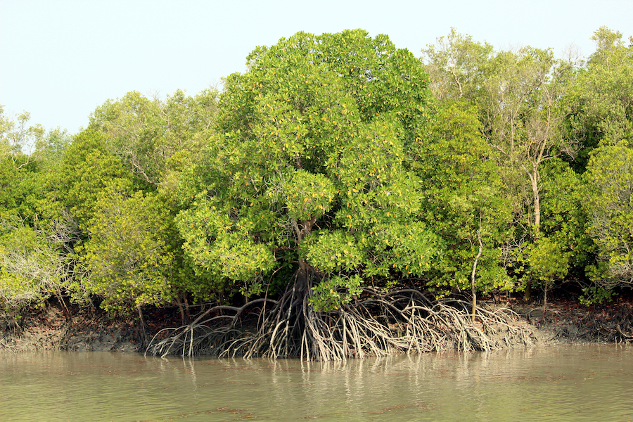
Mangrove Plantation
Mangrove plantations involve the intentional planting and cultivation of mangrove trees along coastlines, estuaries, and lagoons. These unique trees—adapted to saline and tidal conditions—play a vital role in coastal protection, erosion control, and enhancing biodiversity. They also act as a natural barrier, reducing the impact of storm surges and high waves—while their complex root systems stabilize the soil and prevent erosion.
The Sundarbans, spanning India and Bangladesh, is the world’s largest mangrove forest and stands as a testament to the ecological importance and protective capacity of mangroves. This vast area not only supports diverse wildlife, including the Bengal tiger, but also acts as a natural defense against cyclones and tidal surges for the regions it spans.
Planting mangroves requires a clear understanding of the local tidal and saline conditions. The initial step involves site selection, ensuring the location is conducive to mangrove growth. This is followed by site preparation, which might involve clearing non-native vegetation or other obstacles. Once the site is ready, propagules (young plants) or seeds of appropriate mangrove species are planted. Care must be taken to choose species that are native or suitable for the particular region. Post-plantation, regular care, monitoring, and protection from threats like grazing or logging are essential until the trees are well-established.
Application tips:
- Species selection: It’s crucial to plant mangrove species that are native to the area or have proven to be ecologically compatible.
- Monitor salinity: Mangroves thrive in specific salinity ranges. Regularly monitor salinity levels to ensure they’re conducive to the growth of the planted species.
- Protection from disturbance: Young mangroves can be vulnerable to disturbances like human activity or grazing. Protective measures like fencing or community awareness can be beneficial.
- Regular maintenance: While mangroves are hardy—they might need protection from invasive species, pests, or diseases—especially in the early stages.
- Community engagement: In many areas, the success of mangrove plantations relies on local community support and understanding of their importance. Engaging local communities in plantation efforts can ensure the long-term success and protection of these vital ecosystems.
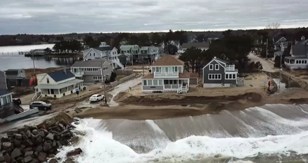
Case Study: Camp Ellis’ Erosion Crisis
Situated in Saco, Maine, Camp Ellis has been grappling with a severe erosion predicament that traces its roots back to a well-intentioned but ill-fated federal project. Originally constructed in the 19th century as a serene coastal area, the erosion challenges at Camp Ellis began escalating in the early 20th century—following the federal government’s decision to build a jetty system. This system was designed to maintain a navigable channel to the Saco River, ensuring smooth maritime operations and safeguarding the area from potential water-borne threats.
However, the very solution intended to protect the region became its Achilles heel. The jetty system inadvertently disrupted the natural sediment flow, which previously replenished the beaches of Camp Ellis. With the beaches deprived of this essential sediment, erosion began to intensify. The outcome of this unforeseen dynamic has been both tragic and profound, leading to the loss of around 36 homes and vast portions of the beach over the years. This erosion crisis imposed an environmental, economic, and emotional burden on the Camp Ellis community—transforming the once-thriving coastal area into a focal point of concern.
In light of the escalating erosion problems, various mitigation efforts were proposed throughout the years—but adequate funding remained a persistent barrier. However, on December 7, 2022, congresswoman Chellie Pingree (D-Maine) heralded a provision in the Fiscal Year 2023 annual National Defense Authorization Act (NDAA) to assign $45 million in federal funding specifically for the Camp Ellis erosion challenge. This announcement followed Congresswoman Pingree’s sustained campaign for enhanced funding.
With this promising financial injection on the horizon, the Camp Ellis community looks forward to a rejuvenated coastline. The focus now shifts to deploying these funds effectively—ensuring that the region’s beaches, homes, and cultural fabric are preserved for future generations.
View the complete article here.
What are effective solutions for preventing coastal erosion caused by storms and hurricanes?
Marine contractors often employ bulkheads, seawalls, revetments, and beach nourishment as effective solutions to mitigate the adverse effects of coastal erosion caused by storms and hurricanes.
How do tidal barriers work, and what role do they play in protecting coastal areas from flooding?
Tidal barriers, also known as storm surge barriers, are designed to prevent sea-based threats like tidal surges from entering estuaries or river mouths, protecting inland areas. They act as temporary sea walls, rising or closing during potential flooding events, while allowing normal tidal flow during regular conditions.