Chapter 2 – Coastal Environment
For a complete version of this document click here.
Coastal design and construction are affected by a number of natural and man-influenced factors. These include the physiography, weather, development patterns, and construction practices for a given coastal regime. This chapter provides a general overview of these factors and their relationship to or influence on residential construction in coastal high hazard areas.
Coastal considerations in dwelling development mainly involve the dynamic beach response to wave energy and water levels. Long-term beach processes are beyond the scope of this manual, but they form an important design checkpoint. Many of our shorelines are moving or naturally eroding, and man’s actions to resist or alter these processes must be undertaken with recognition of both the complexity of the interrelationships and the tremendous energies involved. Erosion of the shore can occur when material supply is reduced and the dynamic beach profile is disrupted. Such erosion is frequently caused when the area between the source of littoral sand and the site under study is disrupted. Such alterations include:
· Damming of waterways that previously carried stream erosion material to the shoreline.
· Building of offshore structures such as breakwaters, jetties, and groins.
· Dredging of offshore channels.
Long-term, gradual shoreline loss and short-term, storm induced scour and erosion are both significant factors to be considered when selecting and building on a coastal site. Long-term erosion rates of 1 to 2 feet per year are common along sandy shorelines, and even greater rates are experienced in areas such as tidal inlets. These longterm effects have a variety of causes, including the present gradual raising of ocean levels due to climatic warming, and dynamic beach processes such as alongshore transport of sand and the accumulation of sand in tidal inlets, capes, jetties, and various other natural and manmade shoreline features (Rogers, 1982). There is concern that the rising sea level is developing from long-range global climatic changes, that it is permanent, not cyclic, and due (or at least related) to what is known as the greenhouse effect. Long-term planning may need to consider permanent sea level rise. The sediment budget and coastal processes in an area should be analyzed to establish historical shoreline behavior patterns and determine housing setback distances.
Short-term erosion and scour at a site can be dramatic over the course of a single storm or storm season. Once exposed by erosion, bulkheads, pilings, and other manmade structures are increasingly attacked by wave action and several feet of scour can occur. Experience has generally shown that it is best to locate structures well away from eroding beaches to avoid the effects of erosion the structure’s expected lifetime. Where this is infeasible, foundations should be designed for the anticipated erosion, rather than relying upon erosion control structures such as seawalls, bulkheads, or rock revetments. Erosion control structures should be built only in areas where protection from an imminent hazard is required.
An assessment of the erosion and storm damage potential at a site can be based on historical and other information available through state coastal zone management agencies, the Corps of Engineers, and state universities. Advisory services such as Sea Grant, the county extension office, and the Soil Conservation Service are good sources and also have personnel familiar with specific local conditions. Long-term residents should not be overlooked as sources of historical flooding and damage information.
Many of the above-named organizations have published information available to assist the siting and construction of coastal structures. The most inclusive and comprehensive source to date is the “Living With The Shore” series by Duke University Press, which when completed will include more than 20 books covering the Atlantic, Pacific, and Great Lakes shorelines.
Beach profile response to storm activity over a short period should be considered. Principal design criteria include beach profile shape, probable storm surge, and incident wave characteristics. Flat beaches signify little storm erosion and relatively slight storm wave action due to the energy dissipation effect over the flat slope. Steep profiles are usually associated with coarse beach sands and indicate an area subject to more severe wave attack. Furthermore, a steeper beach slope to backshore dunes promotes accelerated erosion rates, particularly during periods of abnormally high tide; such a situation warrants increased setback distances. Generally, fine beach material and flat beaches are indicative of less erosion and wave force, while coarse sand and steep beach slopes indicate more forceful erosion and wave action. However, significant erosion can be expected to occur under hurricane conditions even on flat beach slopes.
A beach is constantly in a state of dynamic flux, characterized by two modes of transport: littoral drift alongshore and onshore-offshore movement. Incident wave energy usually breaks onshore at a slight angle to the shoreline, which results in a net component of energy along the coast depending on the wave direction. This combination of breaking waves and angular attack can transport considerable amounts of sand alongshore. Seasonal beach profile changes from erosion and accretion are associated with the incident wave’s height, period, and shape characteristics. Short-period plunging storm waves erode beaches, and longer-period prevailing spilling-type waves cause accretion of foreshore and backshore areas. The width of the beach berm and extent and dimensions of backshore dunes determine the amount of natural storm protection available to coastal dwellings.
To summarize, the particular beach characteristics, the storm and surge history, and the beach profile response to these factors determine desirable location and design of dwelling units and their susceptibility to water level and wave attack. In other words, it is more effective and less costly to design so as to work with nature rather than trying to fight it.
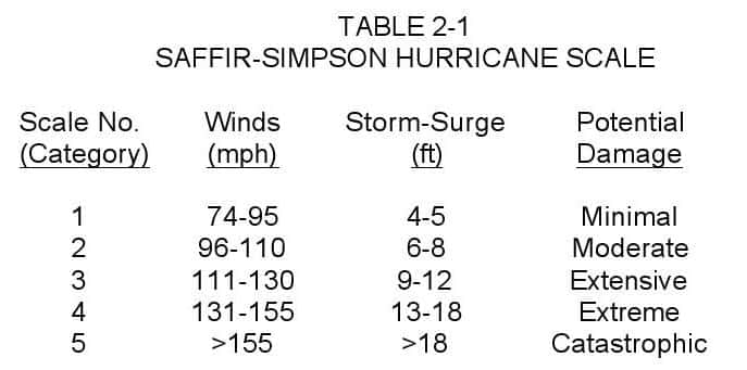
For the purpose of characterizing some of the severe to storms to which the U.S. coastline is subject, the Saffir-Simpson Hurricane Scale is presented in Table 2-1. This scale is used by the National Weather Service to give public safety officials a continuing assessment of the potential for wind and storm-surge damage from a hurricane in progress.
A number of studies of tropical cyclones, including hurricanes, have been made by the National Oceanic and Atmospheric Administration (NOAA). In one study for the period 1886-1970 (Simpson and Lawrence, 1971), tropical cyclones are divided into three categories. One category includes all cyclones whose maximum (reported) sustained winds were 40 mph (gale force) or higher; the second, includes tropical cyclones with reported winds of 74 mph (hurricane force) or higher; the third category “great hurricanes,” characterizes storms with sustained winds of 125 mph or more. Based on these data, areas with a high probability of hurricanes (Figure 2-1) were identified, based on observed past storm occurrences. Sectors not experiencing a “great hurricane” during the period of study are not immune.
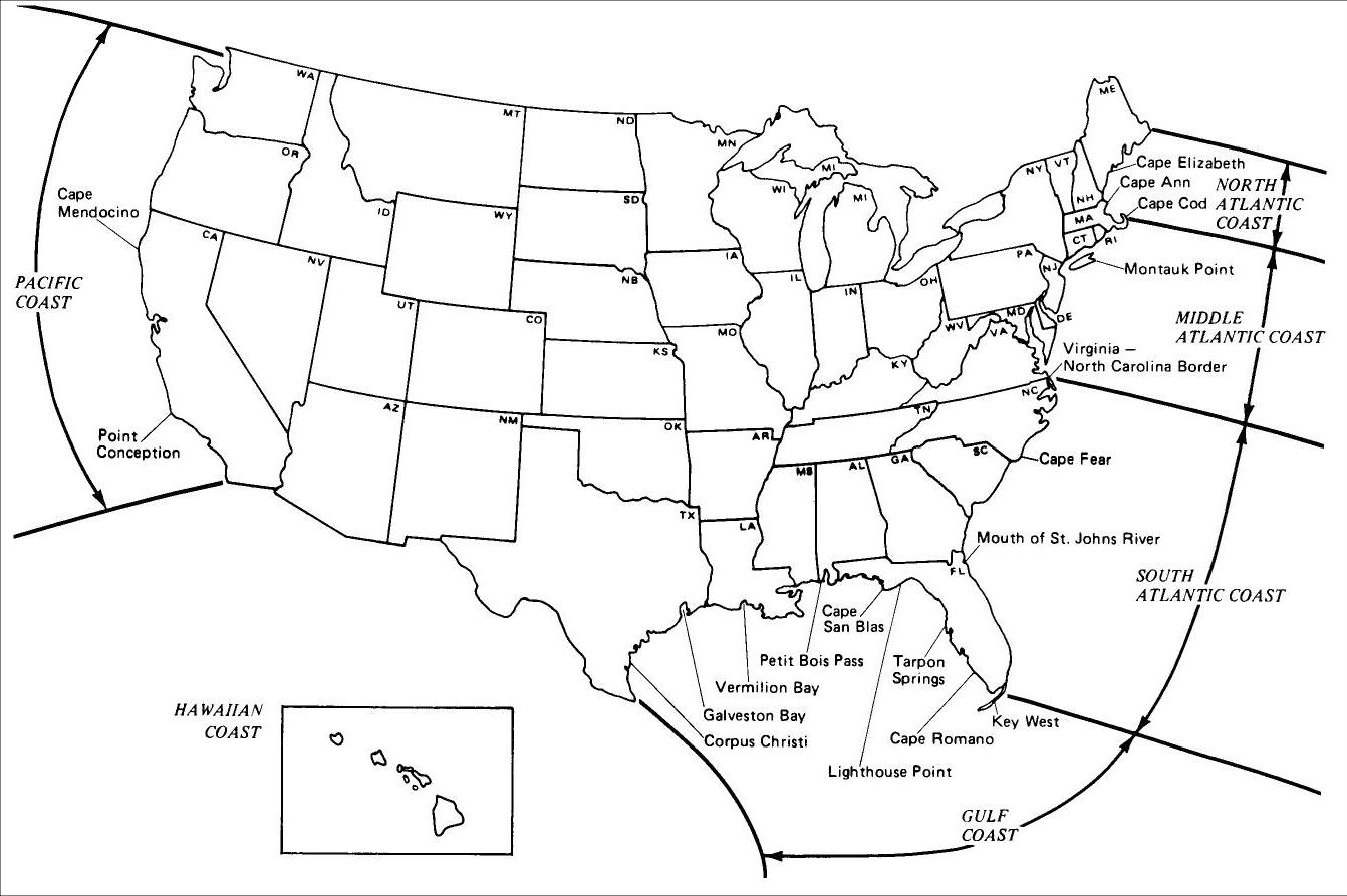
For discussion purposes, the coastline of the contiguous 48 states and Hawaii was divided into six regions and data were collected on historical and current construction practices. Information presented in this manual should be applicable to almost all coastal areas of the United States. Each region has unique general shoreline features, development patterns, and its own storm history. This regionalization serves an additional purpose of providing convenient geographic segments for discussion. Construction and design considerations for Hawaii are not fully included in this document, though a limited amount of information is provided. The designated regions are listed below and are based on the coastal classification scheme of Terrell (1979):
· North Atlantic Coast, the Maine-Canada border south to Cape Cod.
· Middle Atlantic Coast, Cape Cod south to the Virginia-North Carolina border.
· South Atlantic Coast, the Virginia-North Carolina border south to the southern tip of Florida.
· Gulf Coast, the southern tip of Florida west to Mexico.
· Pacific Coast, the California-Mexico border north to the Washington-Canada border.
· Hawaiian Coast, the entire coastline of the Hawaiian Islands.
General descriptions of these differing coastal environments follow. Locations referenced in the text are shown on Figure 2-2.
2.1 NORTH ATLANTIC COAST
The North Atlantic region comprises two general segments in New England, characterized by their differences in terrain and residential development. The natural division between these two areas is Cape Elizabeth, Maine.

From the Maine-Canada border to Cape Elizabeth the coastline is rocky, steep, and deeply incised with numerous bays, estuaries, and islands. There are small areas of mudflat, marshes, and shallow areas but generally the coast is of high energy and experiences high tidal ranges. South of Cape Elizabeth to Cape Cod, the shoreline grades from rocky to sandy, especially south of Cape Ann. Beaches are generally of high energy.
The southern portion of the North Atlantic coastline, through Massachusetts, is heavily populated and extensively developed. This portion of the coastline also contains many older structures, some of which date from the nineteenth century. Both the mainland and the barrier beaches have been developed. Because of the desirability of the properties involved, very small lots with minimal setbacks and little space between residences have resulted. Many residences have been winterized and are inhabited year-round.
The northern portion of the area is much less developed, consisting primarily of rugged terrain, scattered resort residences, rural areas, and fishing villages. Where structures are present, ocean and side yard setbacks are again minimal and there is a tendency toward crowding. The northern portion is much less susceptible to large seasonal influxes of population than the southern portion. Much of the development in both the northern and southern portions of this region either predates construction codes or was constructed under codes with few specific provisions for coastal construction.
The northern New England area experiences a moderate to severe climate, suffering from increasingly harsher winters toward the north. Generally, north of Cape Cod, Massachusetts, the northeaster is the most damaging event and controls design. These are relatively slow moving storms, with large amounts of precipitation and high winds, and are primary cause of coastal flooding erosion. Hurricanes are not as severe a threat as these winter storms.
In general, the Massachusetts coastal area has a continuous fluctuation in weather elements due to its northern latitude and the fact that it is situated in a path followed by lowpressure systems. Statistics developed by the U.S. Army Corps of Engineers in Boston indicate that over the past 50- year period, three or four northeaster-type storms have occurred during each month between November and March. These generally cause at least some damage, such as shingles and shutters being blown away. Hurricanes in 1938 and 1954 as well as northeasters in 1972 and 1978 severely affected the area.
2.2 MIDDLE ATLANTIC COAST
The Middle Atlantic Region also comprises two general segments characterized by their differences in terrain and development; the natural division is Montauk Point. The coastline from Cape Cod to Montauk Point, including Long Island Sound, is fairly irregular with several large islands, bays, and sounds. The beaches are mainly sandy and are variously characterized by high energy areas, marshy areas, barrier islands, and dunes.
From Montauk Point to the Virginia-North Carolina border, the coastline contains wide, sandy, high energy beaches. Extensive marsh areas are protected by a series of barrier islands with dune systems. Estuaries of varying sizes, including Chesapeake Bay and Delaware Bay, are found throughout this portion of the coast.
Development between Cape Cod and Montauk Point is similar to that described above for the southern portion of the North Atlantic coastline. The coastline south of Montauk Point is characterized by resort towns, summer residence communities, and state and Federal park lands and refuges. In several areas, primarily near the mouths of major bays and rivers, harbors have been developed that have fostered considerable growth. Such population centers include New York City, at the mouth of the Hudson River, and the Hampton Roads, Virginia, area at the mouth of Chesapeake Bay. Between these population centers, the coastline has a distinctly rural character, with summer tourism the primary commerce. Much of the land on which resort towns have developed consists of barrier beaches.
Although nineteenth-century structures are at the core of most of the towns, a large amount of construction began after World War II and continues to date. Present-day construction is primarily high-rise apartments and subdivision developments. Generally, lot sizes are larger than those in New England; side yard and especially oceanside setbacks have long been in force, resulting in much less crowded communities than farther north.
In New Jersey and New England, the U.S. Army Corps of Engineers and some municipalities have attempted to halt the landward advance of the ocean with seawalls. Such defenses have not been particularly effective. In the undeveloped coastal areas of Maryland and Delaware, oceanside setbacks and the preservation of dunes have generally prevented shoreline deterioration. In developed areas, however, municipalities and the Corps of Engineers have attempted to stem the littoral drift and erosion of the beaches by constructing groins and jetties, and some homeowners have built individual bulkheads.
The Middle Atlantic States coastline has historically been subjected to numerous coastal storms severe enough to inflict significant property damage. This region averages two to three winter storms each year and an occasional hurricane. The hurricane controls design along this reach of coastline. A severe storm in 1962 caused damage along the Middle Atlantic coast comparable to that inflicted by the February 1978 northeaster in Massachusetts.
The 1962 storm caused major damage to numerous structures, resulting in revised building codes and construction techniques. Because a major portion of the structures in this area received some damage in 1962, newer construction incorporates design and construction techniques that can better resist storm damage. The performance of these newer techniques in less severe recent storms has been substantially better than in 1962. Performance has also been improved in much of this area by restricting development through setback regulations. The Middle Atlantic States received a close call from Hurricane Gloria in September 1985. Gloria had reached…
-
 SPW911 Sheet Pile Design Software
Rated 5.00 out of 5$150.00 – $599.99Price range: $150.00 through $599.99
 -
 Sheet Pile Design (PDF Download)
Rated 5.00 out of 5$89.00
 -
 Pile Driving (PDF Download)
$89.00
-
 Marine Construction Volumes 1 & 2 (PDF Download)
$157.00
-
 Pile Driving (Book)
$89.00


