Chapter 1 – Introduction
For a complete version of this document click here.
1.1 PURPOSE AND SCOPE
This manual provides guidance for the design and construction of coastal residential structures able to resist damage from flood, wind, and erosion hazards. Included herein are discussions of new residential structures–principally detached single-family, attached single-family (townhouse), and low-rise (three-story or less) multifamily houses. Nonresidential structures of similar sizes, loads, and construction can also be considered by interpreting the data and procedures found in this manual, as can retrofitting of existing structures.
This introductory chapter is followed by a general description in Chapter 2 of the coastal regions of the United States, weather conditions, some current construction practices, and generalized shoreline construction considerations. Chapter 3 presents general information and recommendations on site design. Chapter 4 constitutes a major portion of the manual; it describes forces to be resisted, materials used, and many design and construction details. A discussion of application of these coastal construction concepts to larger structures is provided in Chapter 5. Design procedures and worked design examples are presented in Chapter 6 to demonstrate the use of the design tables in the appendices. The appendices present the design data tables, bracing details, detailed design equations and procedures, computer program listings, construction cost information, a sample coastal construction ode, references, individuals contacted in researching this manual, and other pertinent information.
This manual will be of assistance primarily to persons in construction of modest (one- and two-story) residential structures (and similar-sized nonresidential structures) in coastal areas of the United States. Individual home owners, building contractors, and architects or engineers can all apply the information presented in this design manual. Using the data included herein, a design professional may extrapolate for residential (or nonresidential) structures slightly larger than the one- and two-story houses considered in the design equations, charts, and tables and described in the example solutions.
The construction details, design procedures, and charts in this manual are based upon a comprehensive evaluation of many existing beach houses, current construction practices along U.S. coastlines, and various building codes applicable to coastal construction. Practical designs of modest cost and construction details are presented to provide for storm-resistant residential structures.
Examination of both damaged homes (Figure 1-1) and storm-resistant structures along the Atlantic and gulf coasts has demonstrated the desirability of some of the construction details included herein. On the Atlantic coast, public officials, architects, engineers, and builders from Massachusetts to the Florida Keys were interviewed. They contributed ideas, comments, and recommendations on construction in coastal high hazard areas. Similar information was gathered from Florida to Texas along the gulf coast, California for the Pacific coast. This manual presents a composite of recommended and required construction details for the entire U.S. coastline.
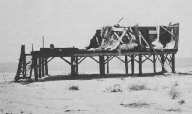 Much information was obtained by evaluating the damage in Alabama caused by Hurricane Frederic in September 1979; Hurricane Alicia, which hit the Texas gulf coast in August 1983; Hurricane Elena, which hit the gulf coast in Florida to eastern Texas in September 1985; and Hurricane Gloria, which in late September 1985 affected the entire east coast before coming ashore on Long Island. Firsthand investigations of the aftermaths of these storms, together with other accounts of storm effects, investigations of current practice, and personal site visits contributed to the material contained in the manual.
Only modest variations in construction practice were found from one geographic location to another. However, for areas subject to higher winds and waves, special attention to erosion and scour is necessary to ensure sufficient lateral support to the foundations. Construction details such as grade beams have been “borrowed” from certain geographic areas to handle this problem. Similarly, foundation bracing is suggested for use in many coastal areas where additional strength is required due to high wind and wave forces. When structures are elevated more to 12 feet above grade, a more substantial bracing system is necessary. A system of trusses built between the elevating piles or poles is recommended to resist lateral forces from wind and waves.
1.2 NATIONAL FLOOD INSURANCE PROGRAM
Initiated by Congress in 1968, broadened and strengthened by amendments in 1969, 1971, and 1973, the National Flood Insurance Program (NFIP) is designed to fulfill one essential purpose: flood hazard mitigation through the amount of property exposed to damage from flooding. The program is administered by the Federal Insurance Administration (FIA) of the Federal Emergency Management Agency (FEMA), and its scope includes all communities identified by FIA as containing flood hazard areas. To date more than 17,500 communities have been so identified, of the approximately 22,000 estimated to contain such areas.
The NFIP is based on the dual principles of making flood insurance available to property owners in flood-prone areas, and of requiring sound flood plain management in flood-prone communities. As long as the community elects to participate in the program, the program offers flood insurance protection for buildings and their contents located in the community.
In return for making flood insurance available, the NFIP requires affected communities to prudently regulate new construction and development in special flood hazard areas. These areas include all land inundated by the flood that has a 1 percent chance of being equalled or exceeded in any given year. This event is known as the “base flood” or “100 year flood” and is used by virtually every Federal agency in the administration of programs related to flood plains. In addition, this same standard is required, either by law or regulation, in many states and is used administratively in the operations of virtually every state’s programs dealing with the use of flood plains.
1.2.1 Emergency Program
The NFIP is administered in two phases: the Emergency Program and the Regular Program.
The function of the Emergency Program is to make flood insurance readily available to property owners throughout flood-prone communities. The operation of the program is simple and direct. FEMA notifies a community that it has been identified as flood prone by providing the community with a Flood Hazard Boundary Map (FHBM). Prepared from the best available data, this map is a preliminary delineation of special flood hazard areas within the community. A community receiving such a map may participate in the program by completing an application to FEMA. Upon approval of the application, limited amounts of Federally subsidized insurance become available in that community.
The limits of coverage for the initial or first-layer insurance protection available under the Emergency Program are $35,000 for single-family structures and $100,000 for all other residential and nonresidential structures. Coverage for the contents of structures may also be purchased. Up to $10,000 per unit may be purchased for residential structures and up to $100,000 per unit may be purchased for nonresidential structures.
1.2.2 Regular Program
Once a community has qualified for the Emergency Phase of the NFIP and insurance protection is available, an extensive technical Flood Insurance Study of the flood hazards in the community is conducted by an engineering contractor for FEMA. This detailed study includes development of a Flood Insurance Rate Map (FIRM) and is conducted at no cost to the community. The flood elevations derived from this study and the resulting FIRM are the basis on which the insurance rates for the community are established and specific flood plain management regulations formulated. Once a community adopts the appropriate flood plain management regulations, the community enters the Regular Program and additional flood insurance coverage becomes available, but at actuarial rates. These rates, based on the severity of the flood hazard, are charged for additional or second-layer coverage for existing structures and for all coverage for new structures. New construction is that which is started after the effective date of the FIRM or December 31,1974, whichever is later.
1.2.3 Plain Management
The specific flood plain management regulations that must be adopted depend to some degree upon the data developed in the detailed insurance study and provided to the community by FEMA. Therefore, these regulations may be adopted incrementally by the community as the necessary data become available. For example, throughout the Emergency Program the community is required to apply minimal flood plain management regulations based on the FHBM and is required to use reasonably any additional data that may be available from other sources to establish the flood elevations.
However, after the Base Flood Elevations (BFE’s) and FIRM are available from FEMA, the community must adopt regulations that will protect any new construction from inundation during the 100 year flood.
FIRM’s prepared for coastal communities depict the 100 year coastal flood plain and the elevations of the 100 year flood. On this type of FIRM, the 100 year coastal flood plain is divided into two adjacent zones that define the different degrees of hazard present, and thus require different flood plain management techniques to satisfy the damage reduction requirements of the NFIP. The V zone (velocity zone) is that portion of the coastal 100 year flood plain that would be inundated by tidal surges with velocity wave action. Generally, the V zone indicates the inland extent of a 3-foot breaking wave, where the stillwater depth during the 100 year flood decreases to less than 4 feet.
The A zone is that portion of the 100 year flood plain not subject to wave action. However, the residual forward momentum of the breaking wave may be present in this zone.
1.2.4 V Zones
The minimum requirements for construction in V zones differ significantly from the minimum requirements for construction in coastal A zones. In V zones, all new construction and substantial improvements to existing structures must be elevated on adequately anchored pilings or columns so that the bottom of the lowest horizontal structural members of the lowest floor (excluding the pilings and columns) is at or above the BFE. A registered professional engineer or architect must certify that the structure is securely fastened to adequately anchored pilings or columns to withstand velocity waters and hurricane wave wash forces. In addition, the space below the lowest floor may be used solely for parking of vehicles, building access, or storage and must be free of obstructions, or may be enclosed with nonsupporting breakaway walls, open wood lattice work, or insect screening intended to collapse under wind and water loads without damaging the elevated portion of the building or the foundation.
FIRM’s published for coastal communities include BFE’s that incorporate wave heights or wave runup associated with the 100 year flood. Due to differing shoreline conditions, FIRM’s for east coast and gulf coast communities include wave heights in BFE’s, while FIRM’s for west coast communities include wave runup. Use of this manual is unaffected by which wave characteristic was used for the applicable FIRM, and the term wave height is generically used.
Additional NFIP standards for V zones require that fill not be used for the structural support of new or substantially improved structures, and that sand dunes and mangrove stands may not be altered so as to increase the potential for flood damage.
1.2.5 A Zones
In coastal A zones, the FIRM identifies the appropriate 100 year flood elevation. The A zone is that portion of the 100 year coastal flood plain subject to wave action of lesser severity. It is important to note that because of momentum of breaking waves, water may be moving at high velocities in this zone, especially in the vicinity of the V zone/A zone interface.
At a minimum, new construction or substantial improvements of residential structures in coastal A zones must be elevated so that the lowest floor (including basements) is at or above the BFE. This elevation may be accomplished through use of fill, raised foundations, or piles or columns.
-
 SPW911 Sheet Pile Design Software
Rated 5.00 out of 5$150.00 – $599.99Price range: $150.00 through $599.99
 -
 Sheet Pile Design (PDF Download)
Rated 5.00 out of 5$89.00
 -
 Pile Driving (PDF Download)
$89.00
-
 Marine Construction Volumes 1 & 2 (PDF Download)
$157.00
-
 Pile Driving (Book)
$89.00


